Disclosure : This site contains affiliate links to products. We may receive a commission for purchases made through these links.
Waterloo – Lasne: Battle of Waterloo Area 20K NGI Belgium Survey Map No. 39/3-4
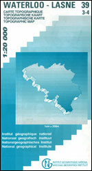
Waterloo – Lanse, map No. 39/3-4 in the topographic survey of Belgium at 1:20,000 covering the main area of the Battle of Waterloo on 18th June 1815 including the Mont St-Jean escarpment, the Lion’s Mound (Lion’s Hillock) and the museum. Although not specifically designed to highlight locations connected with the Battle of Waterloo, the map contains all the information expected of detailed topographic mapping at this scale and provides excellent background for exploring the area with more specialist maps or guides. Map legend includes English. For full specifications of Belgian topographic mapping at 1:20,000 and a list of other titles in this series please click on the series link.

Related Products:
 Nivelles – Genappe: Battle of Waterloo Area 20K NGI Belgium Survey Map No. 39/7-8
 Nivelles NGI Topo 39 – Battle of Waterloo Area
 The Battle of Waterloo
 Ans – Liรจge 20K NGI Belgium Survey Map No. 42/1-2
 Aywaille – Spa NGI Belgium Survey Map No. 49/3-4
Brussels – Zaventem 20K NGI Belgium Survey Map No. 31/3-4
Aywaille – Spa NGI Belgium Survey Map No. 49/3-4
Brussels – Zaventem 20K NGI Belgium Survey Map No. 31/3-4
 Estaimpuis – Pecq 20K NGI Belgium Survey Map No. 37/1-2
Limbourg – Eupen 20K NGI Belgium Survey Map No. 43/5-6
Rumes – Tournai 20K NGI Belgium Survey Map No. 37-5-6
Rebeque – Ittre 20K NGI Belgium Survey Map No. 39/1-2
Braine-le-Comte 20K NGI Belgium Survey Map No. 39/5-6
Celles – Frasnes-lez-Anvaing 20K NGI Belgium Survey Map No. 37/3-4
Antoing – Leuze-en-Hainaut 20K NGI Belgium Survey Map No. 37/7-8
Belgium: 20K Topographic Survey Maps
Estaimpuis – Pecq 20K NGI Belgium Survey Map No. 37/1-2
Limbourg – Eupen 20K NGI Belgium Survey Map No. 43/5-6
Rumes – Tournai 20K NGI Belgium Survey Map No. 37-5-6
Rebeque – Ittre 20K NGI Belgium Survey Map No. 39/1-2
Braine-le-Comte 20K NGI Belgium Survey Map No. 39/5-6
Celles – Frasnes-lez-Anvaing 20K NGI Belgium Survey Map No. 37/3-4
Antoing – Leuze-en-Hainaut 20K NGI Belgium Survey Map No. 37/7-8
Belgium: 20K Topographic Survey Maps
 Belgium: 50K Topographic Survey Maps
Lens – Soignies 20K NGI Belgium Survey Map No. 38/7-8
Belgium: 50K Topographic Survey Maps
Lens – Soignies 20K NGI Belgium Survey Map No. 38/7-8
 Waterloo: A New History of the Battle and its Armies
 Mons NGI Topo 45 – WWI Battlefields
 The Longest Afternoon: The 400 Men Who Decided the Battle of Waterloo
 Le Bizet NGI Topo 36/1-2
 Zonnebeke NGI Topo 28/3-4 – WWI Ypres Salient Battlefields
 Roeselare NGI Topo 19-20 – WWI Ypres Salient Battlefields
 Lo-Reninge NGI Topo 20/5-6 – WWI Ypres Salient Battlefields
 Ieper NGI Topo 28/1-2 – WWI Ypres Salient Battlefields
 Heuvelland NGI Topo 28/5-6 – WWI Ypres Salient Battlefields
 Belgium: 100K Provincial Survey Maps
 Ieper NGI Topo 27-28-36 – WWI Ypres Salient Battlefields
 Sage of Waterloo: A Tale
 How the French Won Waterloo – or Think They Did
 Scott on Waterloo
 Waterloo & Southwark 1914 – 76.3
 Waterloo & Southwark 1894 – 76.2
 Witnessing Waterloo: 12 Hours, 48 Lives, A World Forever Changed
 Kitchener – Waterloo Street Atlas
 Waterloo: The History of Four Days, Three Armies and Three Battles
Belgium: 25K Topographic Survey Maps
Waterloo: The History of Four Days, Three Armies and Three Battles
Belgium: 25K Topographic Survey Maps
 Battle of the Bulge: St Vith
 Waterloo & Beyond: A Tourist Guide to the Battlefield, Museums and More
 Galatzo 25K Mallorca CNIG Topographic Survey Map No. 697-II
Can Picafort 25K Mallorca CNIG Topographic Survey Map No. 672-I
Galatzo 25K Mallorca CNIG Topographic Survey Map No. 697-II
Can Picafort 25K Mallorca CNIG Topographic Survey Map No. 672-I