Disclosure : This site contains affiliate links to products. We may receive a commission for purchases made through these links.
9.78155E+12
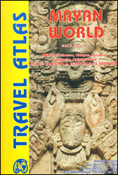
Mayan World Travel Atlas from ITBM combining their mapping of southern Mexico, Guatemala, Belize, Honduras and El Salvador into one A5, paperback atlas with street plans of the capitals and/or enlargements popular areas.All the maps have altitude colouring, although in different grades and in Honduras in feet while the other countries are in metres. Elevation given for spot heights is also not consistent. The maps show the road and rail networks and highlight various places of interest. All the maps have lines of latitude and longitude. Accompanying street plans cover the central parts of the city, show names of main streets and indicate locations of selected hotels and various facilities, etc.The scales are:- Mexico: Yucatan at 1:500,000, plus the states of Tabasco and Chiapas at 1:1,000,000- Guatemala at 1:470,000, with street plans of Guatemala City and Antigua, plus an enlargement of the environs of Guatemala City- Belize at 1:250,000 with a street plan of Belize City- Honduras at 1:750,000 with a street plan of Tegucigalpa- El Salvador at 1:250,000 with an enlargement for the environs of San Salvador

Related Products:
 Yucatan Borch
 Mexico – Guatemala – Belize – El Salvador Marco Polo Road Map
 Belize & Eastern Guatemala ITMB
 Belize Borch
 Mexico Nelles
 Mexico ITMB
 Birds of Central America: Belize, Guatemala, Honduras, El Salvador, Nicaragua, Costa Rica, and Panama
 Mexico Road Map
 Middle East ITMB Travel Atlas
 Mexico Michelin
 Lisbon Borch
 Guatemala ITMB
 Novosibirsk
Mexico Road and Tourist Atlas
Novosibirsk
Mexico Road and Tourist Atlas
 Barcelona Borch
Nuremberg Falk EXTRA Street Plan
Barcelona Borch
Nuremberg Falk EXTRA Street Plan
 Salalah – Governorate of Dhofar Map
 Birds of Mexico and Central America
 Washington DC Borch
 Iasi Cartographia Street Plan
 Guatemala – Belize Reise Know-How
 Arkhangelsk
 San Diego & USA South West Border ITMB
 Irkutsk
 Nuremberg City Pocket Plan
 Pan-Americana North ITMB Travel Atlas: Alaska to Panama
 Riga ITMB
 Washington DC Red Maps
 Madrid Borch
 Dublin Borch
 Caribbean Islands Western Half ITMB Travel Atlas
 Lille and Surroundings Blay-Foldex Street Atlas
 Linz F&B Tourist Street Plan
 New Orleans Borch
 Frankfurt am Main Borch
 Helsinki City Map & Guide
 Vienna F&B Street Atlas
 Alicante and the Towns of the Alicante Province
 Budapest F&B
 Varna
Varna