Disclosure : This site contains affiliate links to products. We may receive a commission for purchases made through these links.
2110 North France Chart Atlas – Nord-Pas-de-Calais, Picardy and Normandy Coasts – 2017 edition
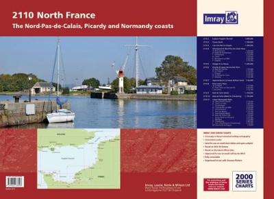
The atlas includes:2110.1 Eastern English Channel1: 600 000 WGS 842110.2 Dover Strait1: 200 000 WGS 842110.3 Cap Gris-Nez to Dieppe1: 200 000 WGS 842110.4 Nieuwpoort & Nord-Pas-de-Calais PlansScales: various WGS 84Plans included:Nieuwpoort (1:30 000)Rade de Dunkerque (1:125 000)Dunkerque (1:25 000)Calais (1:20 000)Boulogne-sur-Mer (1:25 000)รtaples (1:75 000)2110.5 Dieppe to Le Havre1: 200 000 WGS 842110.6 Picardy & Upper Normandy PlansScales: various WGS 84Plans included:Baie de Somme (1:75 000)Le Trรฉport (1:12 500)Dieppe (1:12 500)St-Valรฉry-en-Caux (1:12 500)Fรฉcamp (1:12 500)2110.7 Approaches to Le Havre & River Seine1: 60 000 WGS 842110.8 River Seine PlansScales: various WGS 84Plans included:Le Havre (1:12 500)River Seine to Tancarville (1:63 000)Honfleur (1:12 500)2110.9 Baie de Seine (East)1: 155 000 WGS 842110.10 Baie de Seine (West) to Cherbourg1: 155 000 WGS 842110.11 Lower Normandy PlansScales: various WGS 84Plans included:Deauville/Trouville (1:15 000)Dives-sur-Mer (1:30 000)Ouistreham (1:25 000)Courseulles-sur-Mer (1:20 000)Arromanches (1:35 000)Port-en-Bessin (1:10 000)Grandcamp-Maisy (1:6000)Baie du Grand Vey (1:75 000)Saint-Vaast-La-Hougue (1:20 000)Barfleur (1:15 000)Cherbourg (1:40 000)Port Chantereyne (Cherbourg) (1:10 000)Omonville-la-Rogue (1:7000)

Related Products:
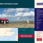 2100 Kent and Sussex Coasts Chart Atlas – 2021 edition
 2300 Dorset and Devon Coasts Chart Pack – 2019 edition
 Nord-Pas-de-Calais – Picardy Michelin Regional 511
 2600 Bristol Channel Chart Atlas – 2016 edition
 557 Pas de Calais et Baie de Somme – SHOM Tidal Stream Atlas
 2000 Suffolk and Essex Chart Atlas – 2018 edition
 563 Cรดte Nord de Bretagne, des Hรฉaux-de-Brรฉhat ร la pointe de Pontusval – SHOM Tidal Stream Atlas
 2500 The Channel Islands and adjacent coast of France Chart Atlas – 2017 edition
 561 Baie de Seine, de Cherbourg ร Fรฉcamp – SHOM Tidal Stream Atlas
 559 Cรดte Ouest de France, de Saint-Nazaire ร Royan – SHOM Tidal Stream Atlas
 SHOM Chart 7424 – Pas de Calais – De Calais ร Dunkerque et de Dover ร North Foreland
 SHOM Chart 7424L – Pas de Calais – De Calais ร Dunkerque et de Dover ร North Foreland – Leisure A4 size
 North France – Calais Cycling Map 3
 2200 Solent Chart Pack: Selsey Bill to Poole, Including the Isle of Wight – 2021 edition
 555 Rade de Brest, Baie de Douarnenez – SHOM Tidal Stream Atlas
 C32 Baie de Seine
 Nord-Pas-de-Calais IGN D721341
 SHOM Chart 7323 – Pas de Calais – De Boulogne-sur-Mer ร Calais et de Dungeness ร Dover
SHOM Chart 7323L – Pas de Calais – De Boulogne-sur-Mer ร Calais et de Dungeness ร Dover – Leisure A4 size
SHOM Chart 7323 – Pas de Calais – De Boulogne-sur-Mer ร Calais et de Dungeness ร Dover
SHOM Chart 7323L – Pas de Calais – De Boulogne-sur-Mer ร Calais et de Dungeness ร Dover – Leisure A4 size
 Admiralty Chart 1462 – Harbours on the North and East Coasts of Scotland
 SHOM Chart 6892 – Baie de Fort-de-France
 Benelux – North France Michelin Road Atlas SPIRAL-BOUND
 565 Golfe de Gascogne – SHOM Tidal Stream Atlas
 Admiralty Chart 368 – Baie de Fort-de-France
 SHOM Chart 6313 – Canal de Sainte-Marie – Partie Nord – Baie de Tintingue
 564 La Manche, de Dunkerque ร Brest – SHOM Tidal Stream Atlas
 558 Cรดte Sud de Bretagne, d`Audierne au Croisic – SHOM Tidal Stream Atlas
 GR2: La Seine ร pied en Ile de France FFRP Topo-guide No. 203
 560 Mer d`Iroise, de l`Ile Vierge a la Pointe de Penmarc`h – SHOM Tidal Stream Atlas
 Normandy `44: D-Day and the Battle for France
 562 Golfe Normand, Breton, de Cherbourg ร Paimpol – SHOM Tidal Stream Atlas
 SHOM Chart 6892L – Baie de Fort-de-France – Leisure A4 size
 SHOM Tidal Stream Atlases – Atlas de Courants de Marรฉe
 Admiralty Chart Folio 25 – Mediterranean Coasts of Spain and France, Strait of Gibraltar to San Remo, incl. Balearic Islands, Corsica and Sardinia
 Admiralty Chart 3525 – Ports on the North and West Coasts of Sabah
 Admiralty Chart 1425 – Ports on the North and East Coasts of Corse
 Admiralty Chart 1202 – Ports on the North and West Coasts of Sardegna
 2120 North Sea Imray Chart Atlas – Nieuwpoort to den Helder – 2019 edition
 566 Pays-de-la-Loire, de la presqu’รฎle de Quiberon ร l’รฎle d’Yeu – SHOM Tidal Stream Atlas
 SHOM Chart 6561 – Carte Conforme Oblique de l’Ocรฉan Atlantique Nord. France-Antilles – Route du Rhum