Disclosure : This site contains affiliate links to products. We may receive a commission for purchases made through these links.
100km around Cape Town
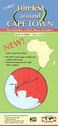
100km Around Cape Town map at 1:150,000 from the locally based Cabex, printed on light, waterproof and tear-resistant plastic paper with on the reverse popular Winelands areas shown with individual wineries, accommodation, etc.On one side is a map at 1:150,000 covering the 150km radius from Cape Town. Coverage extends north to Darling, north-east to Ceres, and east to Worcester and the coastal resorts of Hermanus and Gansbaai. Topography is shown by altitude colouring, with plenty of spot heights and names of mountain ranges, peaks, etc. National parks, nature reserves and other protected areas are highlighted.Road network distinguished between hard and soft surface secondary roads, and includes local roads as well as selected minor gravel roads and off-road tracks. Driving distances are marked on main and secondary roads. Railway lines are shown with stations. On the reverse 15 panels present the popular areas of the Winelands in greater detail, with the overprint showing numerous wineries, as well as restaurants and accommodation facilities.For navigating with GPS the main map has latitude and longitude lines at intervals of 0.25 of a degree. The enlargements on the reverse have no coordinates.


