Disclosure : This site contains affiliate links to products. We may receive a commission for purchases made through these links.
Yorke Peninsula SA
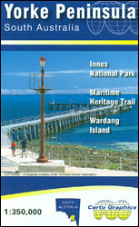
Yorke Peninsula in South Australia on an indexed touring map at 1:350,000 from Carto Graphics, with on the reverse enlargements showing in greater detail the Innes National Park and Warding Island. Coverage extends north to Port Broughton and east to include Adelaide and the coast to the north of the city.On one side is a touring map of the Yorke Peninsula at 1:350,000 showing the region’s road network and highlighting national parks and other protected areas, Aboriginal Lands, and the restricted entry military zone. Driving distances are marked on main and secondary roads. Symbols indicate tourist information centres, surfing and diving sites, boat ramps, viewpoints, etc. Topography is presented by relief shading. Latitude and longitude lines are drawn at 10’ intervals. The index, next to the map, includes a list of parks and reserves. Also provided is a distance table.On the reverse enlargements at 1:50,000 show in greater detail the Innes National Park at the tip of the peninsula, plus the Maritime Heritage Trails around Warding Island (the interior of the island where entry is by permit only does not show any information). Also provided are notes about the area.To see the list of the publisher`s other regional maps of South Australia please click on the series link.


