Disclosure : This site contains affiliate links to products. We may receive a commission for purchases made through these links.
St Cuthbert`s Way Harvey National Trail XT40
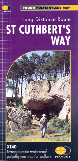
St. Cuthbert`s Way, a 100km / 62.5 mile route from Melrose in the Scottish Borders through the Northumberland National Park to the Holly Island of Lindisfarne, presented at 1:40,000 on a GPS compatible, light, waterproof and tear-resistant map from Harvey Map Services. The route is shown on six panels, with additional small street plans of Melrose, Wooler and Holy Island. Map legend and the accompanying notes plus additional tourist information are also in French and German.Maps in the Harvey’s series covering Great Britain’s national trails and other long-distance footpaths are printed on light, waterproof and tear-resistant synthetic paper and cover the routes at 1:40,000 or 1:60,000. Topography is shown by contours at 15m intervals, with additional spot heights plus colouring and/or graphics to provide a very detailed picture of the terrain (boulder fields, scree, crags, etc) and vegetation / land use (pastures, moorland, woodlands, etc). In Scotland peaks and hills classified as Munros, Corbetts and Donalds are marked. The overprint for the long-distance trail shows sections on local or main roads (highlighting danger points), on tracks, and on footpaths, indicating intermittent or not visible paths. The maps also show other right of way paths, including permissive paths and bridleways. Symbols indicate various facilities and accommodation options (including campsites and youth hostels), pubs and refreshments, food shops, banks, information points, etc, both along the route itself and in the nearby locations. All maps are GPS compatible, with the British National Grid overprinted on each panel. The maps also include useful contact details and general advice.To see other titles in this series please click on the series link.


