Disclosure : This site contains affiliate links to products. We may receive a commission for purchases made through these links.
Greece: Anavasi Hiking Maps of Crete
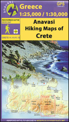
Popular walking areas of Crete on contoured, GPS compatible maps from Anavasi at 1:25,000 โ€“ 1:35,000, printed waterproof and tear-resistant paper. Each title includes on the reverse a specially adapted version of the map where recommended trails are annotated at several points with useful notes for hikers.Topography is shown by contour lines at 20m intervals, hill-shading, and spot heights. The marking for footpaths differentiates between well defined and not discernable ones. Mountain shelters, refuges and campsites are shown, as well as various local landmarks. Road network indicates dirt roads and shows distances on most routes. Place names are shown in both Greek and Latin alphabet. The maps have a UTM grid and latitude / longitude margin ticks or crosshairs at 1` intervals. Map legend includes English. On the reverse most of the area covered by the main map is presented in a version adapted to highlight information of hikers, with publishersโ€ recommendations for best trails and routes annotated with useful notes.


